KeyNote Submission
This curated collection of published or publishable content authored by LAI members showcases our industry’s best thought leadership. Articles and excerpts share a wealth of knowledge — from industry trends and academic research to expert perspectives.
KeyNotes Post Suggestions:
Content for KeyNotes posts consist of land-economics topics and directly relate to a LAI member, chapter, or a global LAI event.
Chapter meeting synopses are perfect for KeyNotes posts as well as articles written by a LAI member or honoring a member.
Personal or business travel that ties in land economics within images and copy are interesting KeyNotes posts.
Peruse past KeyNotes posts for inspiration on crafting a unique post.
Articles of any length are accepted, though long articles may be best broken into a series. Multi-media material such as ppt, charts, video, links to other material, etc. are often integral to substantiating post content.
Bringing Together
Foresight.
And Insight.
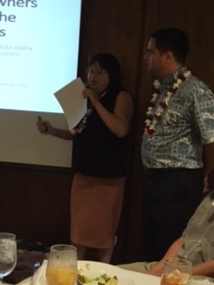
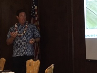
Aloha Chapter Learns about Drone Law and Practice
August 24, 2018
The Aloha chapter met for its quarterly lunch at the Oahu Country Club on June 1 to hear a presentation on drone law and practice by attorneys Janel Yoshimoto and Imram Naeemullah of JMY Law Group LLLC and Steve Hochart, Hawaii Director and Senior Project Manager of Dudek, a consulting firm of planners, engineers and and scientists founded in California with offices in Hawaii. A drone is a small unmanned aircraft system (UAS) or unmanned aerial vehicle (UAV) which for federal regulatory purposes, weighs less than 50 pounds but more than half a pound. Such drones must be registered with the Federal Aviation Agency (FAA). Commercial drones are limited to a maximum speed of 100 mph and a maximum elevation of 400 feet, may not fly over people or out of the visual line of sight of the operator, nor may it approach within 4 miles of an airport. State and local laws regulate how close to private property such drones may fly under 50 feet. Drones may or may not be shot down over private property depending upon the jurisdiction and the level of intrusion into private airspace. Drones are used commercially for surface mapping, inspection of crops or buildings, high-definition imagery, infrastructure inspection, wetland delineation, and subsurface magnetometric mapping, all at a fraction of the cost of more conventional means. Aside from regulation, one of the major limitations on the use of drones is battery life.
David Callies
Scribe/Historian.
![]()